General information
Location
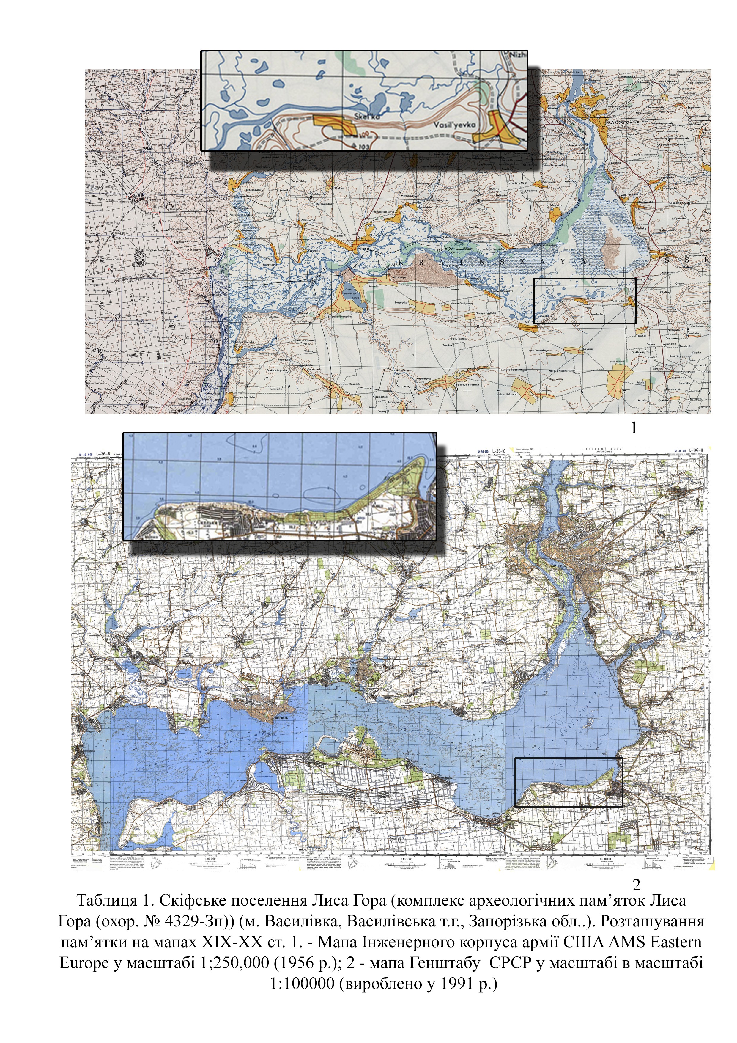
Lysa Hora Cape is located 3.0 north of the northern outskirts of of Vasylivka town, Vasylivka district, Zaporizhzhia region
Kind of cultural heritage
ArchaeologicalObject type
СonstructionsResearch zone
Zaporizhzhia regionMap
Object history and violation description
Velykyi Luh (Great Meadow) is a section of the lower reaches
of the Dnipro river where the left- and right-bank tributaries overflow,
creating a wide floodplain. These river floodplains consist of two main parts,
which are named after the main tributaries: Kinska and Bazavlutska. Travelers
of the 19th century always noted lakes and islands here, where there
is a lot of forest, animals and fish. Thus, here, on an area of 2,155 km², two
different ecosystems coexisted: a dry steppe and a waterlogged forest-steppe.
This has influenced the development of the local population for generations. In
the oral Cossack tradition, Velykyi Luh is the father of all Cossacks.
Lysa Hora is a high triangular cape located in the
southeastern part of Velykyi Luh (Kakhovka Reservoir), above the confluence of
the Karachokrak (Chorna Rika) and Konka (Kynski Vody) rivers.
The tract called Lysa Hora has been mentioned in sources
since the late 18th century. The etymology of the name is related to the
description of a hill without forest. According to various legends, the
mountain was used by evil spirits during a coven; there was an underground
passage with a gazebo where the cursed descendants of Count Popov met with the
devil. According to one of the records, the devil ran away from this town
because of children’s laughter (Tables 1; 2; 4).
According to archaeological and cartographic research, there
was an ancient rectangular fortification on Lysa Hora. In addition, during the
19th and 20th centuries, there was a dirt road through
the marshes to the ferry crossing near the village of Bilenke on the right bank
of the Dnipro (Tables 1,1; 2.).
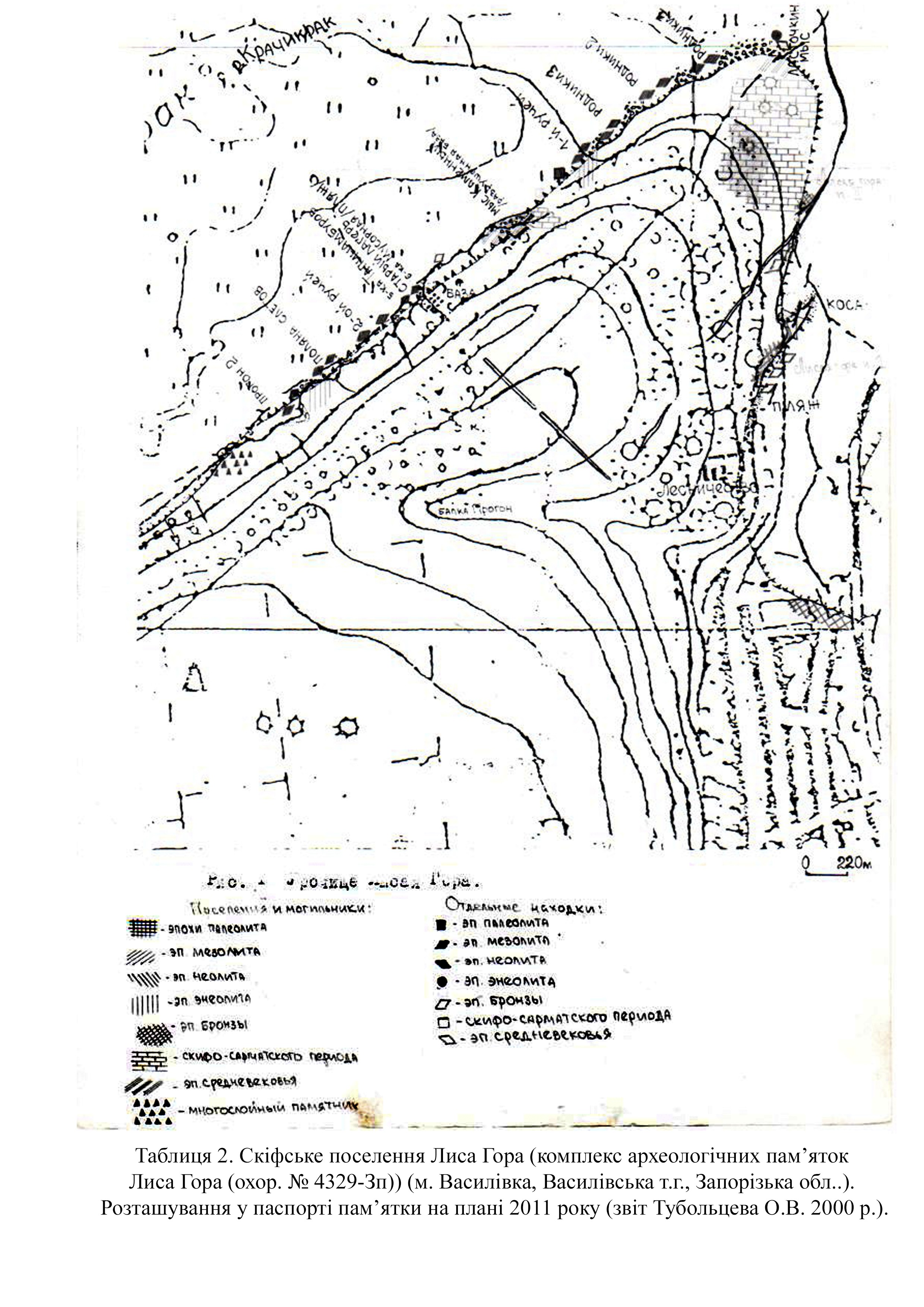
According to the records, the site of the complex monument is detected mainly thanks to partially preserved cultural layers and large accumulations of finds of surface material along the shore of the Dnipro river: from the left bank of the Karachok river in the east to the left bank of the Mayachynska gully in the west (Table 2).
In 1989, by the decision of the Executive Committee of the Zaporizhzhia Regional Council of People's Deputies of December 22, 1982, No. 580 (protection number 1369), the complex of archaeological sites of Lysa Hora was included in the register of monuments of local importance. By the order of the Ministry of Culture and Tourism of February 3, 2010 № 58/0/16-10 (as amended on June 16, 2011 № 453/0/16-11), the monument was included in the State Register of Immovable Monuments of Ukraine and received the protection number 4329-Zp.
According to the results of the observations, the complex of archaeological sites of Lysa Hora has the following general parameters along the Dnipro: length – 16.3 km; width – 0.1–2.9 km (Table 1). The site consists of two distinct parts: eastern Lysa Hora and western adjacent territories. Lysa Hora (70 m) is a compact triangular “natural fortress” (modern dimensions 2.9x2, 4x2.1 km) with a dominant height surrounded by a rectangular rampart in Scythian times. The adjacent sites are located to the west of Lysa Hora (from the confluence of the Maiachynska gully to the Poliana Zletiv gully (Prohon, Pishchana) (Table 2; 4). The high slope of the second terrace begins from this place, which is visibly broken by a dense system of short tributaries (ravines, gullies, rivers). Between them there are gentle elevations – heights with ascents of 105.2, 102.8, 99.7 and 88 meters. The length of this part of the monument is 13.3 meters; the width ranges from 100 to 500 meters.
In the historical context, Lysa Hora is one of the separate sections of the coastal strip of the Kinska part of Velykyi Luh (Tables 1–2). According to estimates by O. Tuboltsev, about 100–700 meters of the shore area, including the high bank and floodplain of the Kinska river (Kinski Vody) with its tributaries, were destroyed and flooded in different areas. It was recorded that the general chronology of the site ranges from the Middle Paleolithic (Cape Prybiinyi) to the Middle Ages (Cape Lastivchyn, Basanka Livoberezhna (Hruzynka)). The overwhelming number of different finds is associated with the high density of settlements, sites and necropolises closer to the mountain. On the adjacent territory, the outcrops of the cultural layer are reduced and tend to be located closer to certain gullies.
The majority of the site of the complex monument Lysa Hora is located in the area of responsibility of the Vasylivka Forestry State Enterprise (71600, Ukraine, Vasylivka district, Zaporizhzhia region, Vasylivka, Lysohorska street, 2-H). After World War II, the site was mostly planted with trees.
The archaeological sites of this area attracted the attention of archaeologists and local historians after the construction of the Kakhovka Reservoir in 1955. As a result of flooding, active and uncontrolled erosion processes began along the entire shore. Consequently, sizeable surface materials began to be collected in various areas along the surf line.
At the first stage, different local historians and archaeologists (I. P. Savovskyi, I. I. Burtsev, O. V. Bodianskyi, I. M. Sharafutdinova, S. M. Liashko, S. M. Kravchenko) collected and mapped the finds separately. Only one site has been excavated and published – the Neolithic Lysohirsk necropolis (O. V. Bodianskyi, 1961). At the second stage, annual stationary research began at two sites: the Scythian Lysohirsk settlement and the Scythian Skelianske soil necropolis. Information about the sites was published in various publications. The work of the expeditions created the basis for further systematic research not only of individual monuments but also for constant monitoring of the shore. Individual barrows and finds were gradually published in various articles (Kravchenko and Tuboltsev 1990; Popandopulo and Busel 2000). Since the beginning of the 20th century, thanks to the coordinated work of archaeologists and local historians, it has been possible to create a unified system of common names of locations and GPS coordinates. One example is the recording of 16 obsidian fragments.
The collection and significance of the Lysa Hora archaeological site complex is difficult to fathom. Some large parts of the materials are stored in the collections of the Zaporizhzhia Regional Museum of Local Lore, the Vasylivka Historical and Architectural Museum-Preserve “Popov's Estate,” the Institute of Archeology of the Academy of Sciences of Ukraine, and the Zaporizhzhia Regional Tourism Center.
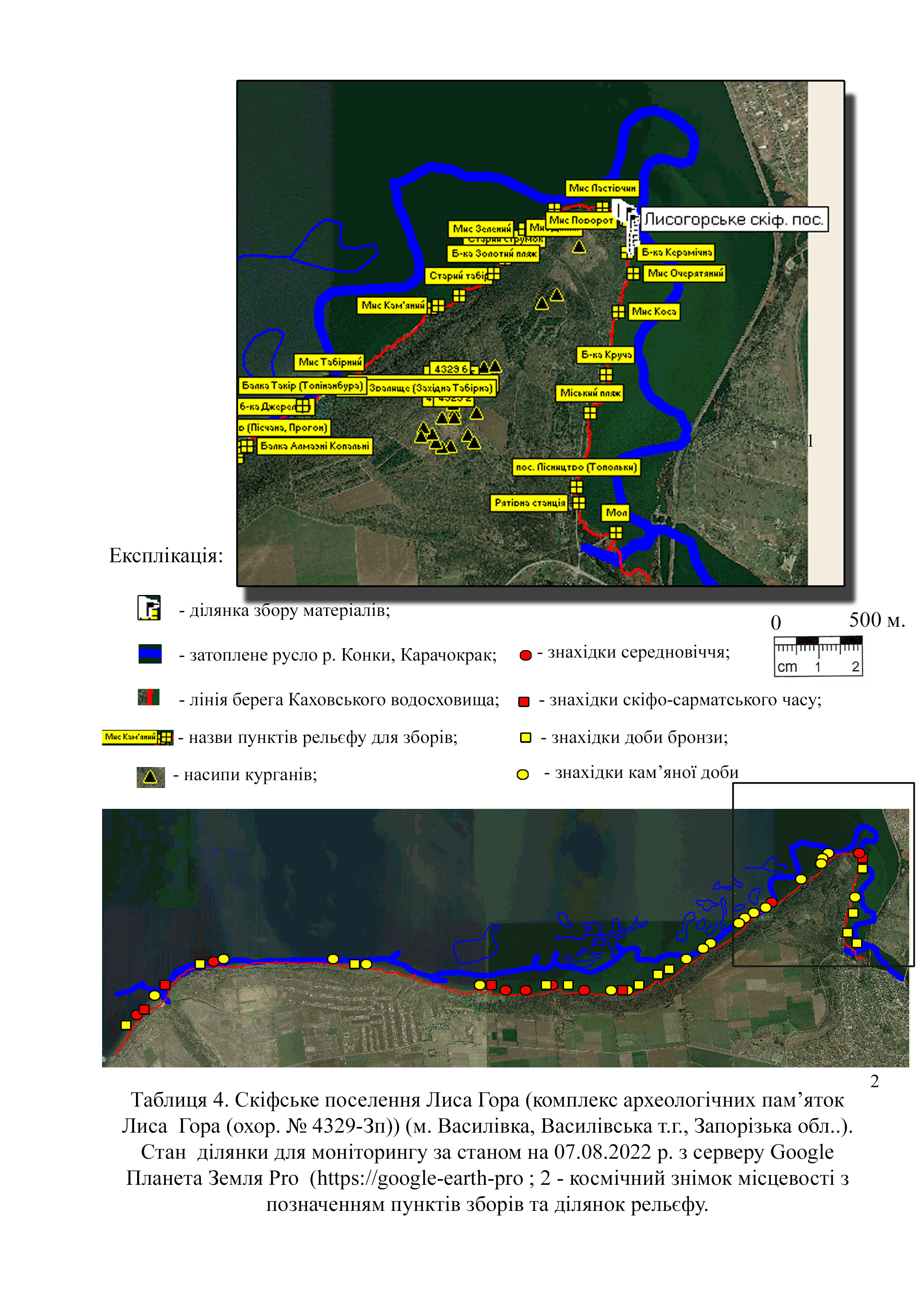
As of 2011, according to Oleh Tuboltsev's estimates, 55 different points of the main groups of finds were recorded on the entire territory of the Lysa Hora Archaeological Site Complex (protection No. 4329-Zp). Among them, only 26 have a partially preserved cultural layer. The investigated Lysohorsk Scythian settlement, Neolithic and Scythian necropolises remain on this list for continued monitoring around the shoreline. According to the records, five large settlements have relatively preserved parts of the monument area. These include the multilayered settlements Lisnytstvo (Topolki), Lysa Hora, Lastivchyn Cape, Prybiinyi Cape, Horikhovyi Hai and seven barrows.
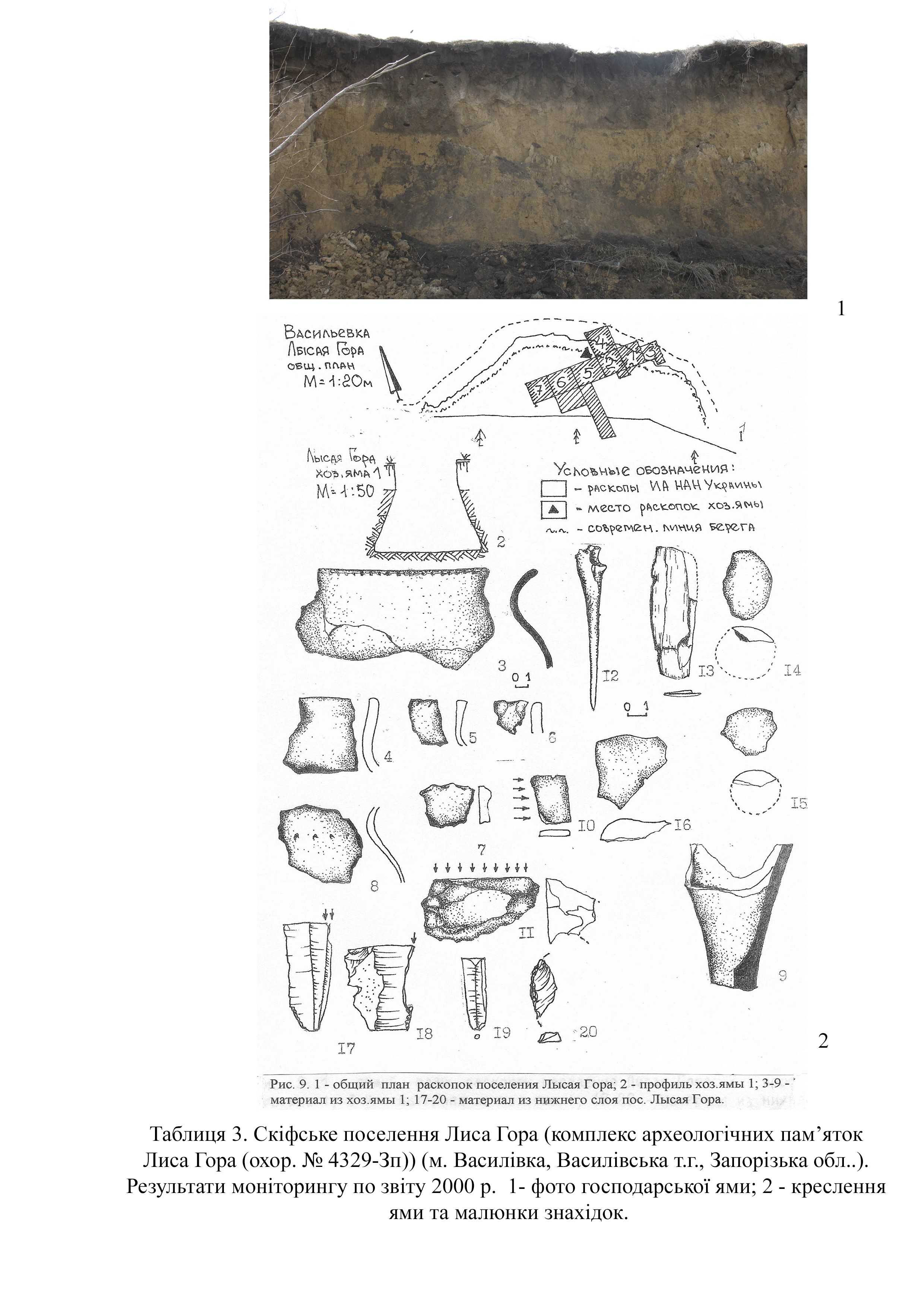
According to the records, Lysa Hora is a multilayered settlement and a soil necropolis with a total area of about 4 hectares (Tables 2; 4). At the excavation site, at a depth of 0.8–1.0 m, the thickness of the cultural layer reaches 20 cm. It was discovered by the staff of the Zaporizhzhia Museum of Local Lore in 1936. From 1984 to 1990, an archaeological expedition of the Institute of Archeology of the National Academy of Sciences of Ukraine led by Havryliuk N.O. and Kravchenko S.M. explored 1,174 square meters. In the southwestern part of the settlement, the remains of a Scythian earthen rampart up to 1.5 m high can be traced. According to the certificate of the site, its lower layers date back to the Mesolithic period (10th – 7th millennium BC). The soil necropolis that occupies the southern part of the settlement dates back to the Bronze Age (2nd – 1st millennia BC). The upper layer belongs to a Scythian settlement (4th century BC). Numerous residential and household buildings, industrial complexes and burials have been examined at the site.
Protection excavations in 1984–1990 allowed preserving and
studying the majority of the material. After the stationary survey, work
continued on fixing and researching pits, burials, and collecting surface
material. The material between the Ocheretiana and Keramichna gullies is
represented by flint and stone items, pottery, iron tools and animal bones
(Tables 3; 4). Satellite images dated August 7, 2022 from the Google Earth Pro
server (https://google-earth-pro)
clearly show the condition of the site (Table 4).
According to the war timeline map, during the offensive in the south, in March 2022, the Kherson (Kakhovka district) and Zaporizhzhia regions (Vasylivka district) were occupied by units of the National Guard of Russia (Deep State map https://deepstatemap.live).
According to Wikipedia, in the first week of September 2022, four of the six units of the Kakhovka HPP were operating, meaning that the station was operating at 2/3 of its installed capacity. Dam malfunctions were noticeable from the very beginning of the war due to the unexpected sharp drop and rise of water during 2022–2024.
On June 6, 2024, the entire dam of the Kakhovka hydroelectric power plant was blown up due to hostilities. Due to the large losses among the civilian population, this is referred to as an act of ecocide committed by the Russian army.
As a result of these actions, the water level throughout the Kakhovka Reservoir (Velykyi Luh) began to drop rapidly. According to Ukrinform, the rate of decline was 15 cm per hour. At that moment, the maximum drop to 4.8 meters was recorded near Zaporizhzhia.
Due to the rapid and uncontrolled change in the water level, the cultural layers of monuments are being destroyed. The impossibility of monitoring the shoreline leads to the destruction of cultural layers of objects in all areas of Velykyi Luh.
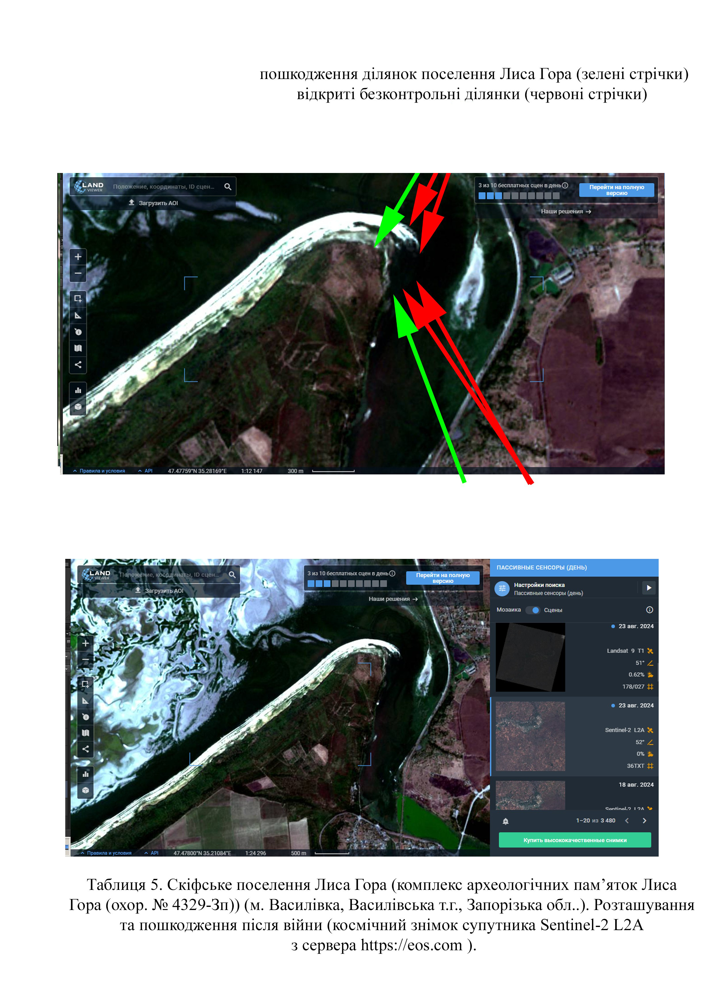
Thanks to space images from August 23, 2024 from the Sentinel-2 L2A satellite (https://eos.com), damage can be calculated. The area of the destroyed parts of the Lysa Hora monument has the following parameters: length – 120 meters; width – 250 meters (area about 8,390 sq m) (Table 5).
The Atesh guerrilla movement published the names of the occupiers suspected of the terrorist attack. Partisans said that servicemen of the 1st battalion of the 205th motorized rifle brigade of the Russian Armed Forces were involved in the terrorist attack. This was confirmed by Oleksii Danilov, head of the National Security and Defense Council of Ukraine. A complete list of military personnel of this unit has been compiled and published (https://www.radiosvoboda.org/a/skhemy-kakhovska-hes-identyfikovani-viyskovi-perekhoplennya/32480831.html).
On June 28, 2023, journalists from the Schemes (Skhemy) project and the Slidstvo.Info agency identified the soldiers of the Russian Federation who were controlling the Kakhovskaya HPP at the time of the explosion. Arsen Pitskhelauri (call sign “Georgian”) and Ruslan Magomedov (sergeant of the engineering and sapper battalion of the 205th Infantry Brigade) are named among the bombers.
Gallery
Additional files
Involved persons
- - Unknown servicemen of the 1st battalion of the 205th motorized rifle brigade of the Russian Armed Forces
- Sergeant of the engineering and sapper battalion of the 205th motorized rifle brigade of the Russian Armed Forces - Magomedov Ruslan
Video gallery
information is clarified
Sources
- Bodyanskiy A. V. (1961). Mogilnik Lysogorskiy epokhi neolita [Lysohirsk necropolis of the Neolithic era]. Kratkiye soobcheniya Instituta Arkheolohii Akademii Nauk Ukrainiskoy SSR. Kyiv, Vol. 11, pp. 32–37.
- Biagi P., Gratuze B., Kiosak D.V., Tuboltzev O.V., Popadopulo Z.H. The Neolithic obsidians from southeastern Ukraine: first characterization and provenance determination//ANATOLIA. -№40. -2014. s. – 1-20.
- Belov A.F., Lyashko S.N. (1978). Poseleniye epokhi bronzy u g. Vasilyevka [Settlement of the Bronze Age near the town of Vasilyevka]. Arkheologicheskiye otkrytiya O 1977. Moscow, p. 298.
- Havriliuk N.O., Olenkovskyi M.P. (1992). Pamiatky skifiv (arkheolohichna karta nyzhnodniprovskoho rehionu [Monuments of the Scythians (archaeological map of the Lower Dnipro region). 5th edition. Kherson, p. 57.
- Havryliuk H. O., Kravchenko S. M. (1995). Pochatok osilosti v stepovykh skifiv (za materialamy poselennia Lysa Hora [The beginning of settled life among the steppe Scythians (based on the materials of the Lysa Hora settlement)]. Arkheolohiia. Kyiv, pp. 85–97.
- opandopoulo Z.Kh. (1999). Otchet o raskopkakh skifskogo gruntovogo mogilnika u s. Skelki Vasilyevskogo rayona Zaporozhskoy oblasti za 1999 g. [Report on the excavations of the Scythian ground burial ground in the village of Skelky of the Vasylivka district of the Zaporizhzhia region in 1999].
- Z. Kh. Popandopulo, V. A. Busel. (2000). Klad liteynykh form iz s. Balki [A hoard of casting molds from the village of Balky]. SSPK. Zaporizhzhia, Volume 8, p. 187.
- Popandopulo Z. Kh. (2011). Skifskiy gruntovyy mogilnik “Skelki” [Scythian ground burial ground Skelky]. Zaporizhzhia, 116 p.
- Kravchenko S.N., Tuboltsev O.V. (1990). Issledovaniye kurgana na Lysoy Gore Vasilyevskogo rayona Zaporozhskoy oblasti v 1985 g. [Investigation of the barrow on Lysa Hora, Vasylivka District, Zaporizhzhia Region in 1985]. Drevnosti Stepnogo Prichernomorya i Kryma. Zaporizhzhia 1990, pp. 91–101.
- Tuboltsev O. V. (1999). Otchet o razvedkakh v Vasilyevskom rayone Zaporozhskoy oblasti v 1999 godu [Report on reconnaissance in the Vasylivka district of the Zaporizhzhia region in 1999].
- Tuboltsev O. V. (2023). Zvit pro naukovi arkheolohichni rozvidky na terytorii o. Khortytsia ta prulehlykh ostroviv ta skel m. Zaporizhzhia v 2023 rotsi [Report on scientific archaeological explorations on the territory of Khortytsia island and adjacent islands and rocks of the city of Zaporizhzhia in 2023].
- Tuboltsev O. V., Busel V. A. (2001). Pamyatniki srednego paleolita mezhdurechya Dnepra i Konki [Monuments of the Middle Paleolithic between the Dnipro and Konka rivers]. Muzeinyi visnyk, Zaporizhzhia, pp. 9–16.
- Lyashko S.N. (2001). K arkheologicheskoy karte Zaporozhskoy oblasti (Lysaya Gora u g. Vasilyevka) [To the archeological map of the Zaporizhzhia region (Lysa Hora near the town of Vasylivka)] Muzeinyi visnyk, Zaporizhzhia, No. 1., pp. 23–29.