General information
Location
Community - Novoazovsk district
City - Obryv village
Kind of cultural heritage
ArchaeologicalObject type
СonstructionsViolation type
Damage Destruction Illegal archaeological excavations Items/artifacts removed during illegal archaeological excavationsResearch zone
Donetsk regionMap
Object history and violation description
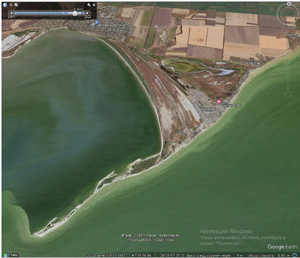
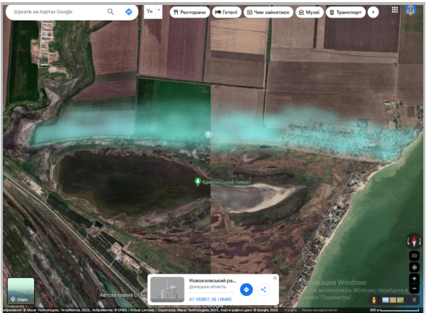
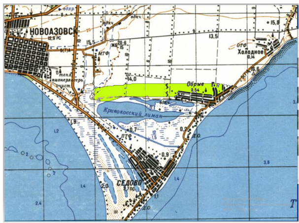
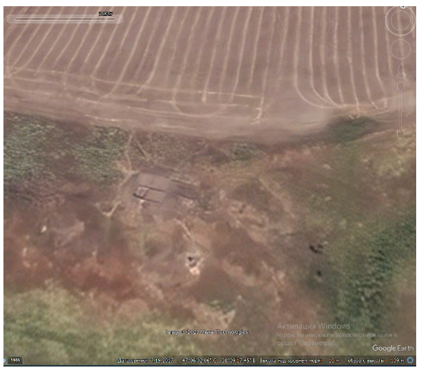
The Obryv (“Precipice”) complex archaeological site is located on the fluvial terrace of Taganrog Bay west of Obryv village of Novoazovsk district. The southern side of the terrace affords a picturesque view of a series of currently degrading coastal estuaries, whose alluvial shores closer to the sea gradually merge, forming Kryva (Crooked) Spit – a modern zoological natural monument of local importance. From the western side, the monument is bounded by the Shyroka gully with a watercourse, which is a source of flowing fresh water. The surface of the terrace is gentle and flat, which makes it convenient for economic activities and housing. Taken together, such conditions probably made this section of the Azov coast attractive for people in the past (pictures 1, 2). According to previous research, virtually the entire, almost five-kilometer-long terrace, including the territory of the present-day village, is the so-called "settlement strip," whose width, as per archaeological explorations, is within 300 meters (1, 2). Archaeological materials from the Neolithic, the Bronze Age, and the Middle Ages have been detected at the monument. Over the course of research, a certain cyclical distribution of locations with uneven percentages of cultural remains dating back to different periods caused individual sites within the monument to be singled out as monuments with their own numbering (for example, Obryv 1, 2, ... 5). Furthermore, on the edge of the terrace, in its middle part, there is a small barrow. In the 1980s, the Donetsk archaeologist A.N. Usachuk conducted archaeological explorations at the settlement. As of now, the majority of its area is built up with modern buildings and is being plowed. Data about the monument are included in the register of archaeological sites of Donetsk region under numbers 6208–6213.
Since the summer of 2014, the territory of Novoazovsk district of Donetsk regions has been temporarily occupied by the hybrid armed formations of the Russian Federation. In the course of implementing measures to legalize its presence in Ukraine, the occupying authorities represented by the leadership of the so-called Donetsk People’s Republic attempted to attract as much international attention as possible by virtue of implementing cultural and scientific projects with Russian support (which were also probably planned by Russian curators). One of the directions of this activity was the conduct of archaeological excavations with the involvement in the organization and execution of works of former scientific workers of Ukraine, who remained in occupied Donetsk and became collaborators.
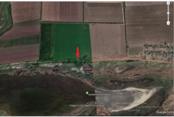
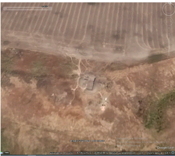
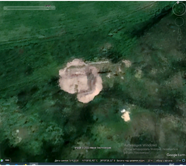
As part of the project for the remote monitoring of cultural heritage sites, the site of illegal archaeological works was determined, which was widely reported in the media in the temporarily occupied territories of Ukraine. The excavations were organized and carried out by representatives of the occupation administration of the so-called DPR under the direct leadership of Aleksandr Kolesnik and Eduard Kravchenko. According to data acquire via remote monitoring, the total lost area of the illegally destratified cultural layer of the Obryv settlement as of 2021 is no less than 150 square meters.
During 2016–2018, the Obryv monument complex was subjected to illegal excavations by representatives of the so-called DPR, which caused significant damage to the cultural layer of the monument. Items from illegal excavations were also removed; unfortunately, their qualitative and quantitative composition is not known for sure. The date of the destructive impact on the archaeological site, verified by means of remote monitoring, covers the period from 2016 to 2018.
Gallery
Additional files
information is clarified
Involved persons
- - The occupying administration of the so-called DPR
- - Aleksandr Kolesnik
- - Eduard Kravchenko
Video gallery
information is clarified
Sources
- Pryvalova O. Ya., Pryvalov A. I. (1988). Spysok pamiatok arkheolohii Ukrainy. Donetska oblast [List of archeological sites of Ukraine. Donetsk region]. Kyiv: UOOP.
- Usachuk A.N. (1981). Novi poselennia doby bronzy v pivnichno-skhidnomu Pryazovi [New Bronze Age Settlements in North-Eastern Azov]. Topical Problems of Archaeological Research in the Ukrainian SSR: Abstracts of report for the All-Ukrainian Conference of Young Scientists. Kyiv.