General information
Location
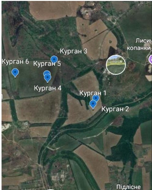
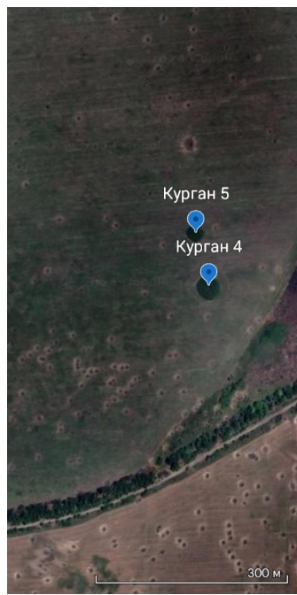
Barrow 5 is situated on a watershed plateau 3.05 km northwest of Pidlisne village of the Siverskodonetsk district, Luhansk region.
Kind of cultural heritage
ArchaeologicalObject type
СonstructionsViolation type
information is clarifiedResearch zone
Luhansk regionMap
Object history and violation description
Pidlisne village is part of the Popasna city community of the Siverskodonetsk district, Luhansk region. The village is 20 km away from Lysychansk and 35 km away from Popasna.
Barrow 5 is located on a watershed plateau 3.05 km northwest of Pidlisne village, or 50 meters north of barrow 4. It measures 1.3 meters in height and 30 meters in diameter. The size of the barrow is average among those found in the Luhansk region. Most barrows here rarely exceed 3 meters in height and 30 meters in diameter and date back to the Bronze Age (late 4th – late 2nd millennium BC), mainly to the Middle (27th – 21st centuries BC) and Late (18th – 13th centuries) periods.
The barrow is of local importance and is a newly discovered one. It is not included in the register of immovable archaeological sites.
On the territory of the Luhansk region, the barrow funeral rite began to be used in the Early Aeneolithic era and is associated with the population of the Skelianska culture (second quarter of the 5th – early 4th millennium BC). The Copper Age period (Aeneolithic) was the time when the first shepherds appeared on the historical scene in Ukraine and, with them, burial structures known in the oral tradition as graves and barrows. Since then, they have been an integral part of the steppe landscape. But they became numerous here during the Bronze Age, the heyday of the Ancient Eastern civilizations. In the Luhansk region during the Bronze Age, this funerary tradition is associated with the population of the Yamna (32nd–25th centuries BC), Catacomb (27th–21st centuries BC), Babynska (21st–18th centuries BC) and Zrubna (18th–13th centuries BC) cultural communities. Based on the spread of the barrow rite (and thus the carriers of “barrow” cultures of the Aeneolithic-Bronze Age), researchers study the migration of Indo-European tribes across Europe and Asia.
The most common burials in Luhansk barrows are those of the Catacomb and Zrubna cultures. There is reason to believe that the population growth in the Donetsk-Luhansk region was the consequence of the presence of copper ore deposits that attracted the ancient population. In this respect, the barrow is more interesting owing to its location only 40 kilometers away from copper ore deposits in the Bakhmut Hollow.
There are much fewer Early Iron Age barrows in the region associated with the Cimmerians (9th–8th centuries BC), Scythians (7th–3rd centuries BC), Sarmatians (2nd century BC–4th century AD) and the Middle Ages, when the region was inhabited by the Bulgars, Pechenegs, Torks and Cumans (6th–13th centuries).
External features of the barrows, including their size, suggest the time of their construction. Among the funerary dowries of people buried during the Iron Age there are precious metal items.
With the beginning of the full-scale Russian invasion of Ukraine in February 2022, the Russian Armed Forces, including the 2nd Army Corps of the so-called Lugansk People’s Republic, advanced in the south of the Ukrainian government-controlled part of the Luhansk region, taking it under their control. Despite the fact that there was a very strong and reliable fortified area in the area of Zolote, the breakthrough was made from the direction of Horikhove – Toshkivka. The Russian troops came from two directions. One was aimed at Zolote, and the other part went to the rear, including the village of Pidlisne. The village and its surroundings were repeatedly shelled by tanks, mortars, cannon artillery, multiple rocket launchers and aircraft of the Russian armed forces. On June 21, 2022, Pidlisne village was occupied.
Under such circumstances, the protection zone of the barrow was violated. Shell craters are recorded 6 meters to the southeast, 13 meters to the east and 32 meters to the southwest of the barrow mound. The diameter of the shell holes reaches up to 4 meters.
Gallery
Additional files
information is clarified
Involved persons
- - It is the Russian armed forces that perpetrated the violation of the hemline of the barrow and its protection zone.
Video gallery
information is clarified
Sources
information is clarified
Links
- Pidlisne village (Siverskodonetsk district)
- The invaders have captured the villages of Pidlisne and Myrna Dolyna in Luhansk region, - General Staff of the Armed Forces of Ukraine
- The occupiers have captured the settlements of Pidlisne and Myrna Dolyna, - General Staff
- Russian occupiers capture two villages in Luhansk region
- Russians capture two more villages in Luhansk region – Haiday
- Russian troops captured two villages in Luhansk region