General information
Location
Community - Dokuchaievsk community
City - 1.7 km south of Liubivka village
Donetsk region
Kind of cultural heritage
ArchaeologicalObject type
СonstructionsViolation type
information is clarifiedResearch zone
Donetsk regionMap
Object history and violation description
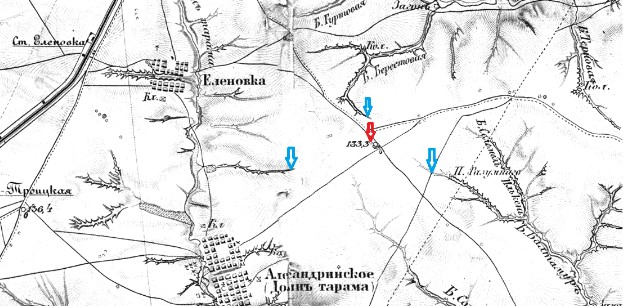
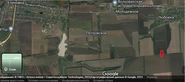
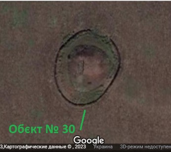
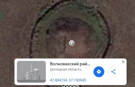
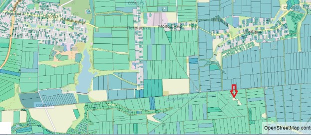
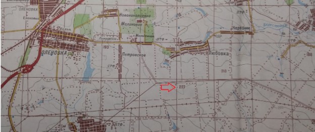
The barrow is located 1.7 km south of Liubivka village of Dokuchaievsk community. The visible diameter of the embankment, which has survived until the present day, is 37 meters. It is the main one in the barrow group consisting of several (at least six) barrows located in a chain, some of which were filled up and thus connected in ancient times (pictures No. 1 and No. 5.). The main axis of the barrow group is oriented northwest to southeast. On the 19th-century historical map by Friedrich von Schubert, the group is localized as eminence 133.3 (in fathoms according to the Russian measurement system). Data from modern space photographs indicate that as of the summer of 2021, the barrow group was in an extremely dangerous condition, having been nearly completely destroyed by plowing (1). At this moment, only the tops of two barrows retain the remains of a protective sod cover (pictures No. 2 and 3). The data of the Public Cadastral Map of Ukraine indicate that the barrows are included in the State Register of Archaeological Sites; the land plots they occupy are withdrawn from land use (picture No. 5). It is all the more unfortunate that in the period 2014–2015, representatives of illegal armed formations of the so-called DPR damaged the barrow by creating a caponier* on its top and by digging a circular trench in its lower part, which is subjected to tillage (this situation, in our opinion, requires some explanation, which is provided in caption to picture No. 7). According to modern space images, the strongpoint was not in use in the summer of 2021, as evidenced by the absence of traces of visits on the arable field.
Digital data carriers with an electronic list of archeological sites of Donetsk region and relevant cartographic materials were removed from the archeology department of the Donetsk Regional Museum of Local Lore by unknown armed persons in the summer of 2014, during the occupation of Donetsk city by Russian hybrid armed formations. As of today, they are officially considered lost. As part of the project on remote monitoring of cultural heritage sites, the damaged archaeological objects have been assigned internal conventional numbers.
*Caponier (from the French caponniere, meaning “niche”) is a defensive structure that allows generating flank or enfilade (oblique) fire in two opposite directions.
Gallery
Additional files
information is clarified
Involved persons
information is clarified
Video gallery
information is clarified
Sources
Links
information is clarified