General information
Location
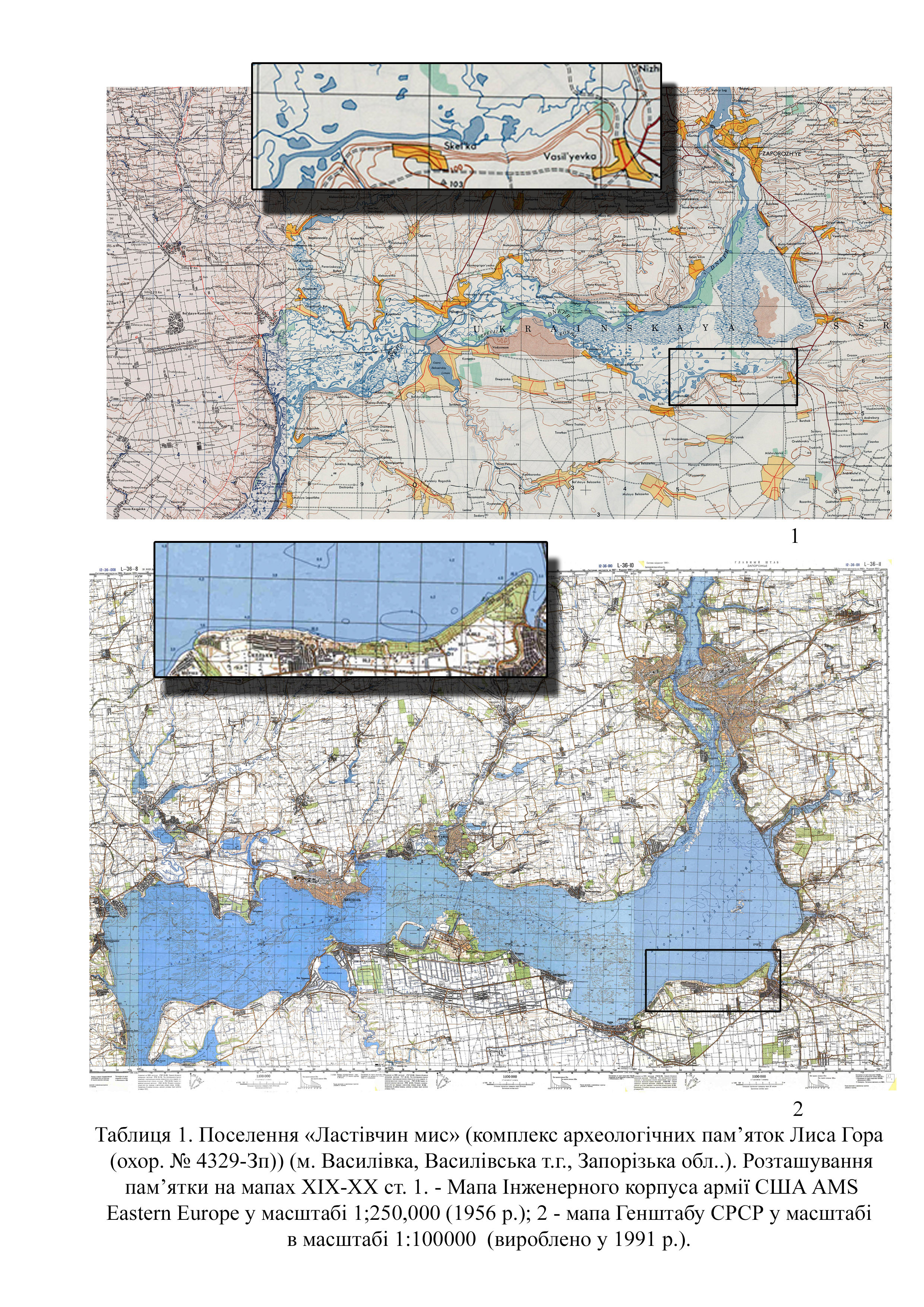
Lysa Hora Cape is situated 3.0 km north of the northern outskirts of Vasylivka town, Vasylivka district, Zaporizhzhia region
Kind of cultural heritage
ArchaeologicalObject type
СonstructionsViolation type
DamageResearch zone
Zaporizhzhia regionMap
Object history and violation description
Velykyi Luh (“Great Meadow”) is a section of the lower reaches of the Dnipro river where the left- and right-bank tributaries overflow, creating favorable conditions for a wide floodplain. These reed beds consist of two main parts, which are named after their main tributaries: Kinska and Bazavlutska. Travelers of the 19th century always noted lakes and islands here, where there is a lot of woods, animals and fish. Thus, here, on an area of 2,155 km², two different ecosystems coexisted: a dry steppe and a waterlogged forest-steppe. This influenced the development of the local population for generations. In the oral Cossack tradition, Velykyi Luh is the father of all Cossacks.
Lysa Hora (“Bald Mountain”) is a high triangular cape located in the southeastern part of Velykyi Luh (Kakhovka Reservoir), above the confluence of the Karachokrak (Crimean Tatar for “Black river”) and Konka (Kinski Vody) rivers.
The tract called Lysa Hora has been mentioned in sources since the late 18th century. The etymology of the name is related to the description of a hill without woods. According to various legends, the mountain was used by evil spirits during a coven; there was an underground passage with a gazebo where the cursed descendants of Count Popov met with the devil. According to one of the records, the devil ran away from this town because of children's laughter (Tables 1; 2; 4).
As archaeological and cartographic research found, there was an ancient rectangular fortification on Lysa Hora. In addition, during the 19th and 20th centuries there was a dirt road through the reed bed to the ferry crossing near the village of Bilenke on the right bank of the Dnipro river (Tables 1,1; 2.).
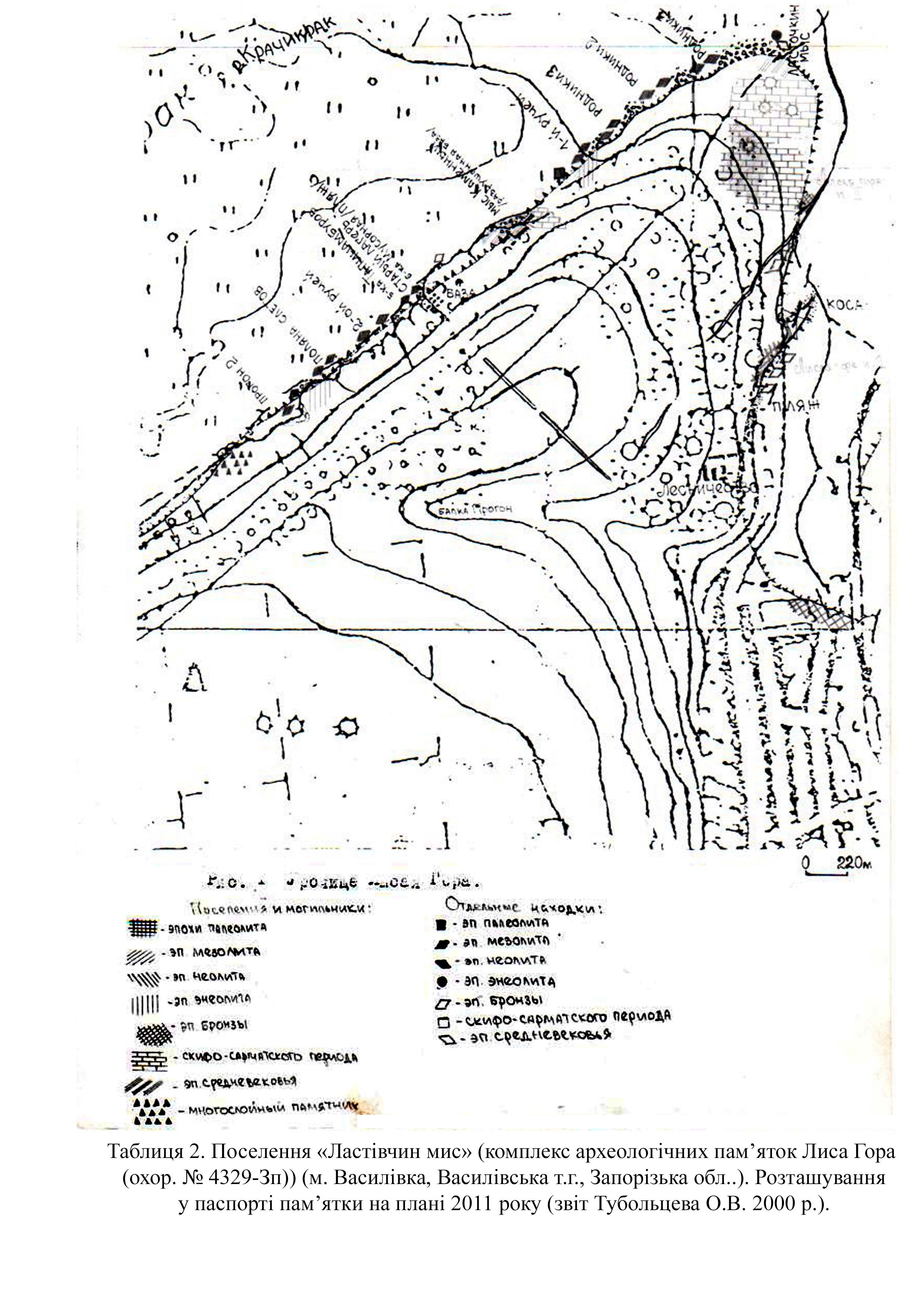
According to the records, the area of the complex site is recorded mainly from partially preserved cultural layers and large accumulations of finds of surface material along the Dnipro river shore: from the left bank of the Karachok river in the east to the left bank of the Maiachynska gully in the west (Table 2).
In 1989, by the decision of the Executive Committee of the Zaporizhzhia Regional Council of People's Deputies of December 22, 1982 No. 580 (protection number 1369), the complex of archaeological sites of Lysa Hora was included in the register of monuments of local importance. By the order of the Ministry of Culture and Tourism of February 3, 2010 № 58/0/16-10 (as amended on June 16, 2011 № 453/0/16-11), the monument was included in the State Register of Immovable Monuments of Ukraine and received the protection number 4329-Zp.
According to observation findings, the complex of archaeological sites of Lysa Hora has the following general parameters along the Dnipro: length – 16.3 km; width – 0.1–2.9 km (Table 1). The site consists of two distinct parts: eastern Lysa Hora and western adjacent territories. The elevation of Lysa Hora (70 m) is a compact triangular “natural fortress” (modern dimensions are 2.9x2.4x2.1 km) with a dominant height surrounded by a rectangular rampart in Scythian times. The sites adjacent to his territory are located to the west of Lysa Hora (from the depression of the Maiachynska gully to the Poliana Zletiv gully (Prohon, Pishchana) (Table 2; 4). The high slope of the second terrace begins from this place, which is visibly broken by a dense system of short tributaries (ravines, gullies, rivers). Between them there are gentle elevations – heights with ascents: 105.2, 102.8, 99.7 and 88 meters. The length of this part of the monument is 13.3 meters; the width is from 100 to 500 meters.
Historically speaking, Lysa Hora is one of the separate sections of the shore strip of the Konka part of Velykyi Luh (Tables 1–2). According to estimates by O. Tuboltsev, about 100–700 meters of the shore area, including the high bank and floodplain of the Kinska river (Kinski Vody) with its tributaries, were destroyed and flooded in different areas. It is recorded that the general chronology of the site ranges from the Middle Paleolithic (Cape Prybiinyi) to the Middle Ages (Cape Lastochyn, Basanka Livoberezhna (Hruzynka)). The overwhelming number of different finds is associated with the high density of settlements, sites and necropolises closer to the mountain. On the adjacent territory, the outcrops of the cultural layer are smaller and tend to be located closer to certain gullies.
The site of the complex monument Lysa Hora is, for the most part, located in the area of responsibility of the Vasylivka Forestry State Enterprise (71600, Ukraine, Vasylivka district, Zaporizhzhia region, Vasylivka, 2-H Lysohirska street). After World War II, the site was mostly planted with trees.
The archaeological sites of this territory attracted the attention of archaeologists and local historians after the construction of the Kakhovka reservoir in 1955. As a result of the flooding, active erosion processes went uncontrolled along the entire shore. Consequently, numerous surface materials began to be collected at various sites along the surf line.
At the first stage, different local historians and archaeologists (I. P. Savovskyi, I. I. Burtsev, O. V. Bodianskyi, I. M. Sharafutdinova, S. M. Liashko, S. M. Kravchenko) collected and mapped the finds separately. Only one site has been excavated and published – the Neolithic Lysohirsk necropolis (O. V. Bodianskyi, 1961). At the second stage, annual stationary research began at two sites: the Scythian Lysohirsk settlement and the Scythian Skelianske soil necropolis. Information about the sites was published in various publications. The work of the expeditions created the basis for further systematic research not only of individual monuments but also for constant monitoring of the shore. Individual barrows and finds were gradually published in various articles (Kravchenko and Tuboltsev 1990; Popandopulo and Busel 2000). Since the beginning of the 20th century, thanks to the coordinated work of archaeologists and local historians, it has been possible to create a unified system of common names of locations and GPS coordinates. The detection of 16 obsidian fragments can be considered an example.
The collection and significance of the Lysa Hora archaeological site complex is difficult to fathom. Some large parts of the materials are stored in the collections of the Zaporizhzhia Regional Museum of Local Lore of the Zaporizhzhia Regional Council, the Vasylivka Historical and Architectural Museum-Preserve “Popov's Estate” of the Zaporizhzhia Regional Council, the Institute of Archeology of the Academy of Sciences of Ukraine and the Zaporizhzhia Regional Tourism Center of the Zaporizhzhia Regional Council.
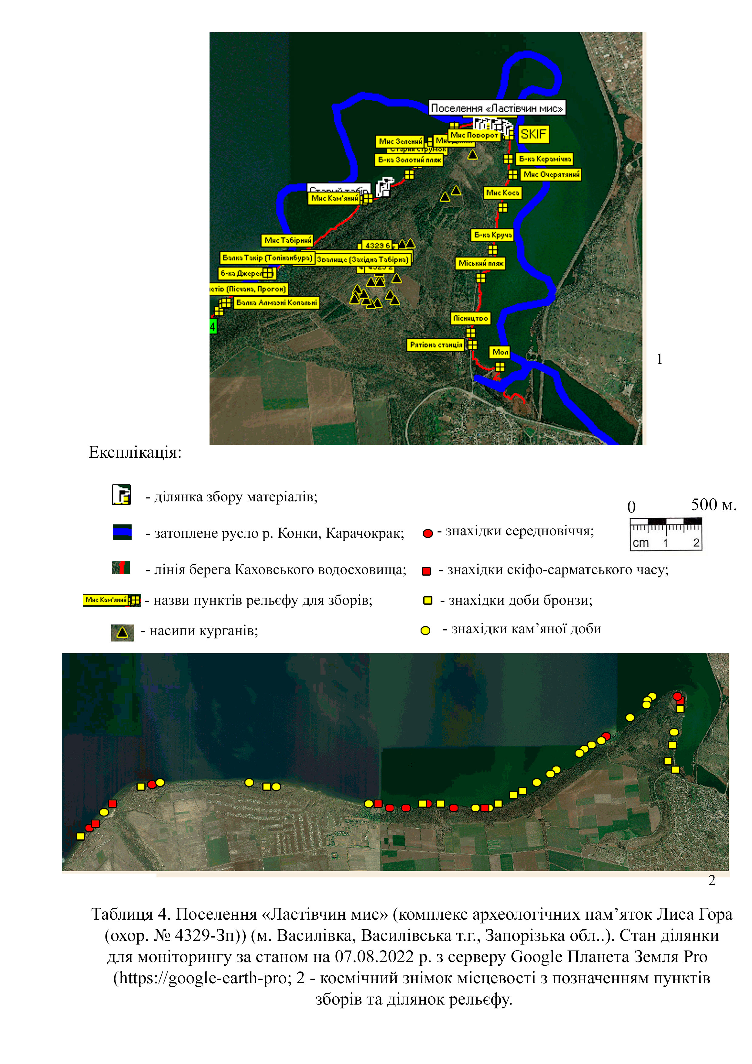
As of 2011, according to Oleh Tuboltsev's estimates, 55 different points of the main groups of finds were recorded on the entire territory of the Lysa Hora Archaeological Site Complex (protection No. 4329-Zp). Among them, only 26 have a partially preserved cultural layer. The investigated Lysohorsk Scythian settlement, Neolithic and Scythian necropolises remain on this list for continued monitoring around the shoreline. According to the records, five large settlements have relatively preserved parts of the monument area. These include the multilayered settlements of Lisnytstvo (Topolki), Lysa Hora, Lastivchyn Cape, Prybiinyi Cape, Horikhovyi Hai and seven barrows.
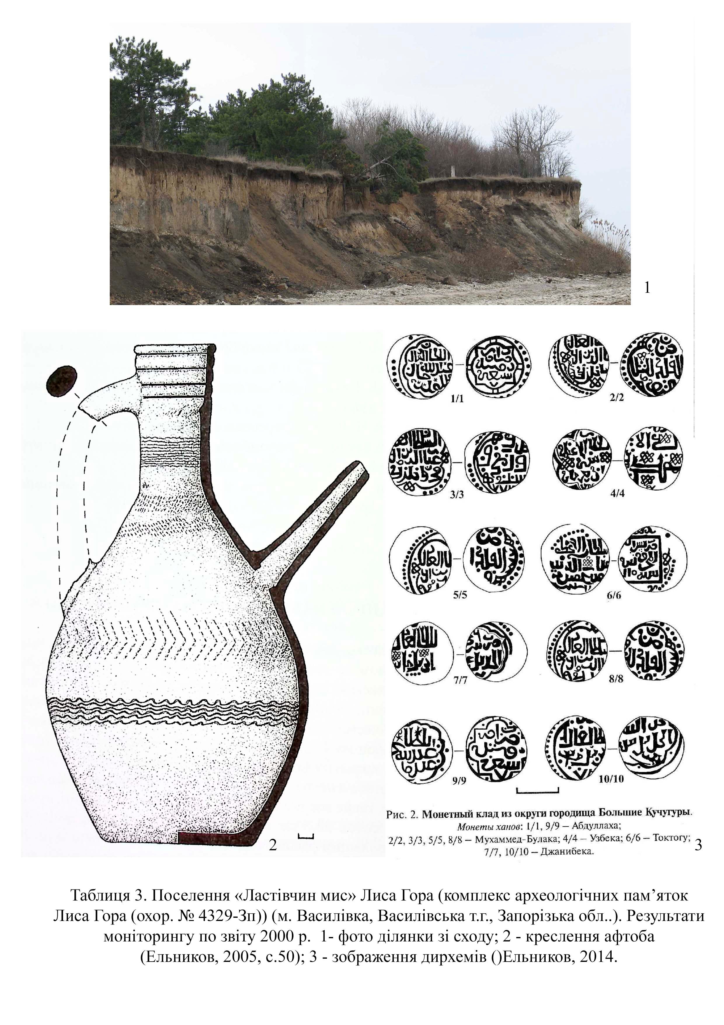
Lastivchyn Cape settlement is located in the northern part of Cape Lysa Hora, between Cape Povorot and Cape Dykyi (Table 2; 4.1). The site can be seen thanks to the remains of several large deep dugouts along the shore (Table 3.1). Near the dwellings, local lore specialists at various times found small fragments of ceramic dishes, a stone pestle, a fragment of a fluted medieval amphora and a part of an aftabeh (kumgan, a pitcher made out of clay). The latter was found and reconstructed by Serhii Tverdokhlebov, an employee of the Zaporizhzhia Regional Tourism Center of the Zaporizhzhia Regional Council, in 1984. The vessel was published by Mykhailo Yelnikov, an archaeologist and PhD in History at the Zaporizhzhia Polytechnic National University (Table 3.2). He attributes it to the Golden Horde period, when craft traditions spread rapidly and complemented each other.
In 1986, during an expedition of the Institute of Archeology of the National Academy of Sciences of Ukraine led by Dr. Nadiia Havryliuk, a blacksmith's burial with two pots and a large set of tools, including blacksmith's tongs and a saw blade, was found near the medieval dugouts.
In addition to the information about the area of Lastivchyn Mys settlement, it should be added that a treasure trove of 117 dirhams was found 1.1 km east of the last dugout during the construction of the old camp in the 1960s. They are now lost. In 2010, during a severe drop in water level, a local lore specialist found a new hoard of 30 coins. Information about the discovery was published by Mykhailo Yelnikov, an archaeologist and PhD student at the Zaporizhzhia Polytechnic National University. The find dates from the period of 1310–1376, the time of the rise of the Golden Horde under the leadership of beklarbek (commander) Mamai, before Tokhtamysh's invasion in 1380 (Table 3.3).
In addition to the above, numerous finds of pottery, coins, jewelry and mirrors have been recorded on the territory of the Lysa Hora archaeological site (protection No. 4329-Zp). The area around the site is connected with the large Golden Horde city of Velyki Kuchuhury (Mamai Sarai), located 7.5 km to the north in the center of Velykyi Luh, which was partially explored by an archaeological expedition of the Institute of Archaeology of the National Academy of Sciences. In addition, a Muslim settlement and necropolis were found and partially excavated on the right bank of the Karachokrak river, opposite Lysa Hora. It may be related to the place name Ak-Mechet (Aktar Mosque) on the map of the famous Italian cartographer Rizzi Zannoni.
According to the war timeline map, during the offensive in the South, in March 2022, Kherson (Kakhovka district) and Zaporizhzhia regions (Vasylivka district) were occupied by units of the National Guard of Russia (Deep State Map https://deepstatemap.live).
According to Wikipedia, in the first week of September 2022, four of the six units of the Kakhovka HPP were operating, meaning that the station was operating at 2/3 of its installed capacity. Dam malfunctions were noticeable from the very beginning of the war due to the unexpected sharp drop and rise of water during 2022–2024.
On June 6, 2023, the entire dam of the Kakhovka hydroelectric power plant was blown up due to hostilities. This crime is referred to as an act of ecocide committed by the Russian army.
As a result of these actions, the water level throughout the Kakhovka Reservoir (Velykyi Luh) began to drop rapidly. According to Ukrinform, the rate of decline was 15 cm per hour. At that moment, the maximum drop to 4.8 meters was recorded near Zaporizhzhia.
Due to the rapid and uncontrolled change in the water level, the cultural layers of the sites are being destroyed. The impossibility of monitoring the shoreline leads to the destruction of cultural layers of objects in all areas of Velykyi Luh.
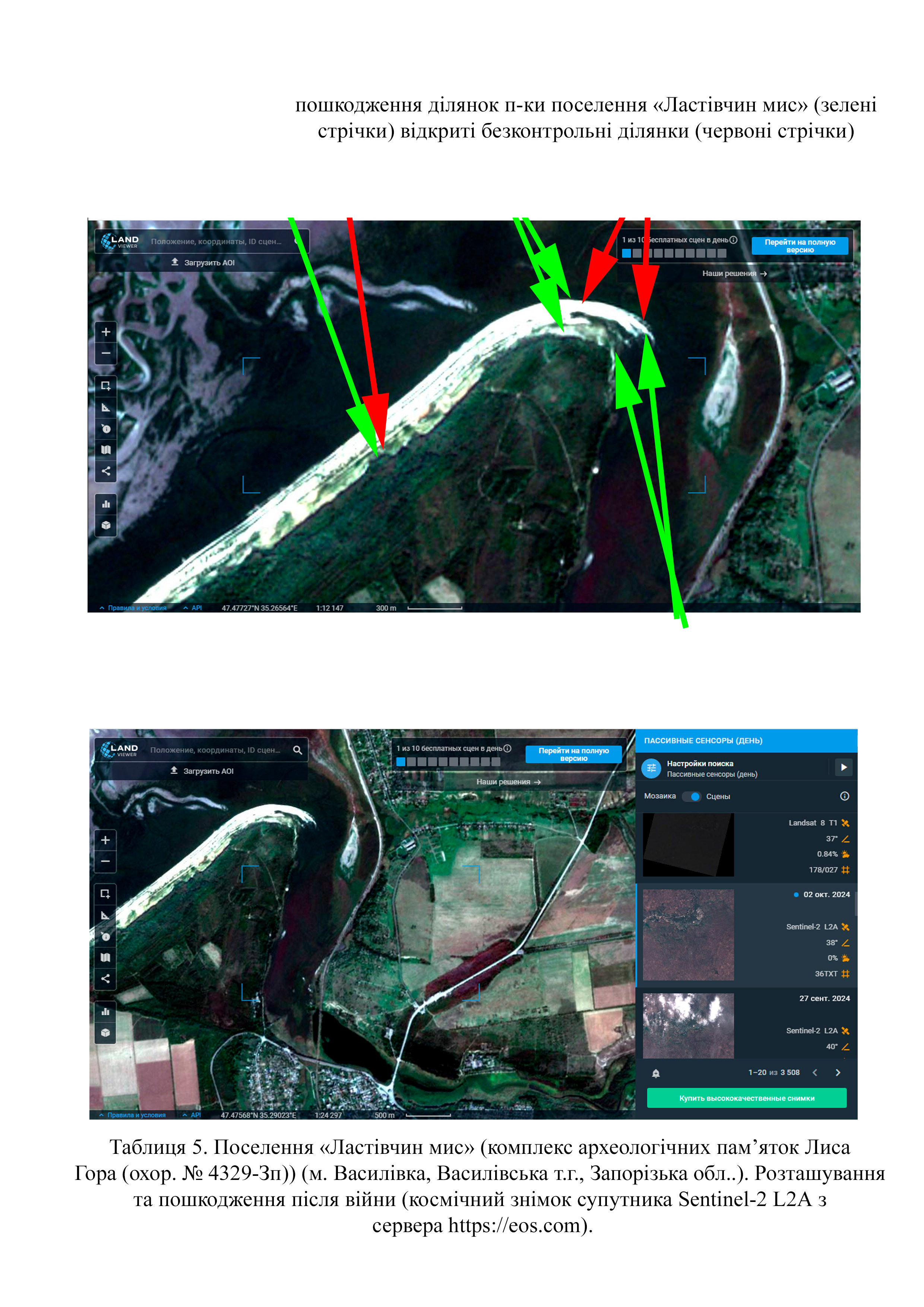
Thanks to satellite images from October 2, 2024 from the Sentinel-2 L2a satellite (website https://eos.com), it is possible to calculate the damage. The area of the destroyed parts of the Lastivchyn Mys site has the following parameters: length – 463 meters; width – 144 meters (approximate area – 66,672 square meters) (Table 5).
The Atesh guerrilla movement published the names of the occupiers suspected of the attack. The guerrillas claimed that soldiers of the 1st Battalion of the 205th Motorized Rifle Brigade of the Russian Armed Forces were involved in the attack. This was confirmed by the head of the National Security and Defense Council of Ukraine, Oleksii Danilov. A full list of the military of this unit has been compiled and published (https://www.radiosvoboda.org/a/skhemy-kakhovska-hes-identyfikovani-viyskovi-perekhoplennya/32480831.html).
On June 28, 2023, journalists from the Schemes (Skhemy) project and the Slidstvo.Info agency identified the soldiers of the Russian Federation who were controlling the Kakhovka HPP at the time of the explosion. Arsen Pitskhelauri (call sign “Georgian”) and Ruslan Magomedov (sergeant of the Engineer and Sapper Battalion of the 205th Separate Motorized Rifle Brigade) are named among the bombers.
Gallery
Additional files
Involved persons
information is clarified
Video gallery
information is clarified
Sources
- Bodyanskiy A. V. (1962). Skifskoye pogrebeniye s latinskim mechom [Scythian burial with a Latin sword]. Sovetskaya arkheologiya, pp. 272–276.
- Bodyanskiy A. V. (1961). Mogilnik Lysogorskiy epokhi neolita [Lysohirsk necropolis of the Neolithic era]. Kratkiye soobcheniya Instituta Arkheolohii Akademii Nauk Ukrainiskoy SSR. Kyiv, Vol. 11, pp. 32–37.
- Yelnikov M.V. (2005). Sluchaynaya Nakhodka aftoba v urochishche Lysaya Gora [Accidental discovery of aftabeh in Lysa Hora tract]. Muzeinyi visnyk, pp. 49–52.
- Yelnikov M.V. (2014). Klad dirkhemov iz okrestnostey zolotoordynskogo gorodishcha Bolshyye Kuchugury [Hoard of dirhams from the outskirts of the Golden Horde hillfort Velyki Kuchuhury]. Starozhytnosti livoberezhnoho Podniprovia. Kyiv-Poltava, pp. 79–94.
- Biagi P., Gratuze B., Kiosak D.V., Tuboltzev O.V., Popadopulo Z.H. (2014). The Neolithic obsidians from southeastern Ukraine: first characterization and provenance determination. ANATOLIA, No. 40, pp. 1–20.
- Belov A.F., Lyashko S.N. (1978). Poseleniye epokhi bronzy u g. Vasilyevka [Settlement of the Bronze Age near the town of Vasilyevka]. Arkheologicheskiye otkrytiya. 1977. Moscow, p. 298.
- Havriliuk N.O., Olenkovskyi M.P. (1992). Pamiatky skifiv (arkheolohichna karta nyzhnodniprovskoho rehionu [Monuments of the Scythians (archaeological map of the Lower Dnipro region). 5th edition. Kherson, p. 57.
- Havryliuk H. O., Kravchenko S. M. (1995). Pochatok osilosti v stepovykh skifiv (za materialamy poselennia Lysa Hora [The beginning of settled life among the steppe Scythians (based on the materials of the Lysa Hora settlement)]. Arkheolohiia. Kyiv, pp. 85–97.
- Dovzheniuk V.Y. (1961). Tatarske misto na nyzhnomu Dnipri chasiv piznoho serednovichchia [Tatar city in the lower reaches of the Dnipro in late Middle Ages]. Arkheolohichni pamiatky, Vol. 10, pp. 175–193.
- Z. Kh. Popandopulo, V. A. Busel. (2000). Klad liteynykh form iz s. Balki [A hoard of casting molds from the village of Balky]. Starozhytnosti stepovoho Prychornomoria (SSPK). Zaporizhzhia, Vol. 8, p. 187.
- Popandopulo, Z. Kh. (2011). Skifskiy gruntovyy mogilnik “Skelky” [Scythian earthen necropolis “Skelky”]. Zaporizhzhia, 116 p.
- Kravchenko S.N., Tuboltsev O.V. (1990). Issledovaniye kurgana na Lysoy Gore Vasilyevskogo rayona Zaporozhskoy oblasti v 1985 g. [Investigation of the barrow on Lysa Hora, Vasylivka District, Zaporizhzhia Region in 1985]. Drevnosti Stepnogo Prichernomorya i Kryma. Zaporizhzhia 1990, pp. 91–101.
- Tikhomolova I.R. (1997). Poseleniye i mogilnik XIV v. u s. Verkhnyaya Krinitsa [Settlement and necropolis of the 14th century near Verkhnia Krynytsia village]. Drevnosti stepnogo Prichernomorya i Kryma (DSPK). Zaporizhzhia, Vol. 6, pp. 5–9.
- Tuboltsev O. V. (2000). Otchet o razvedkakh v Vasilyevskom rayone Zaporozhskoy oblasti v 1999 godu [Report on explorations in the Vasylivka district of the Zaporizhzhia region in 1999]. Archive of the Zaporizhzhia Inspection for the Protection of Monuments of History and Culture. D-5.
- Tuboltsev O. V. (2023). Zvit pro naukovi arkheolohichni rozvidky na terytorii o. Khortytsia ta prulehlykh ostroviv ta skel m. Zaporizhzhia v 2023 rotsi [Report on scientific archaeological explorations on the territory of Khortytsia island and adjacent islands and rocks of the city of Zaporizhzhia in 2023].
- Tuboltsev O. V., Busel V. A. (2001). Pamyatniki srednego paleolita mezhdurechya Dnepra i Konki [Monuments of the Middle Paleolithic between the Dnipro and Konka rivers]. Muzeinyi visnyk, Zaporizhzhia, pp. 9–16.